![]()
![]()
![]()
![]()
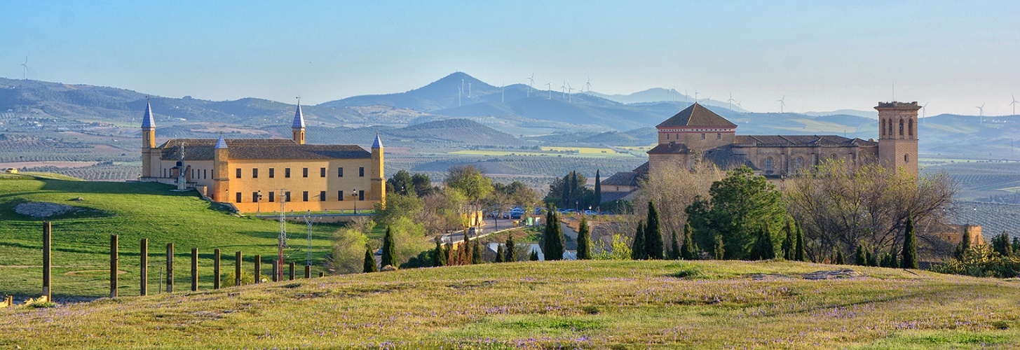

Cycling Routes
Mountain biking is a sport activity considered risky, which is mainly carried out on roads and trails, preferably using and recovering the traditional system of communication routes. Mountain biking contributes to the development of rural tourism, bringing people closer to the natural environment and knowledge of the area through its heritage and ethnographic elements. This sports practice consisting of touring different rural or mountain areas is a comforting way of joining physical activity, culture and the environment. It can be done at any time of the year and on any terrain, being a recommended activity because it is carried out in a pleasant environment, if it is carried out with the appropriate security measures there are not too many risks. This sport is intended for anyone who is passionate about nature, observing the landscape, recovering tranquility and abandoning the stress of daily life. In this way, in addition to enjoying everything that the march offers, the activity can be reconciled with other hobbies such as the practice of photography, and interest in flora and fauna. The route of each route can be done in one direction or the other, with the desired duration, which allows you to enjoy it as a family. Sometimes there are deviations that allow you to shorten or lengthen the route, and access monuments or places of special interest.
In the same way, these routes are a good tourist offer for lovers of mountain biking and nature, since they allow all the means to be in direct contact with the territory, with its people and with the natural characteristics that make it unique. compared to other places.
For this route that we are going to describe, we take the Municipal Sports Center as the starting and ending point. In this itinerary we will start by making a gentle descent for approximately halfway up the route to go back up until we return to Osuna. We leave the Municipal Sports Center and take the “Camino del Ejido”, in the curve we turn left to reach the “SE-712” road (Lantejuela Road), we cross it and we go around the social orchards to continue on the road which is heading towards the Écija road, we will see roads to the left, but we must take the last one before reaching the road turning left. We go down the path of the fruit trees until we reach the "Vereda de las Ánimas", we turn left to take it and cross the "Arroyo del Salado". We keep to the right and then turn left into the “Vereda de los Mártires” and continue along it, reaching the “Cortijo de Casablanca”, once here we turn left and cross the “SE-712” road (Carretera de Lantejuela) going straight, just before crossing the "Arroyo del Peinado" we must turn right to go parallel to the stream until we reach a crossroads where we must turn left to cross a bridge and enter the "Vereda de Ojén ”arriving at the“ Cortijo de los Veneros ”.
We continue crossing the “SE-716” road and arrive at the “Cortijo de Ojén”, we turn left entering the “Vereda de Lucena”, we continue without deviating along the sidewalk until we finally reach a crossroads where we turn left to take the "Vereda Real del Alamillo" and continue through the "Cortijo del Taraje", after doing so we will find a fork, we keep left until we reach the "Cortijo del Alamillo", we walk a few meters on the asphalt and just before the next curve, to the left we take the “Vereda Real del Alamillo”, we are close to the “SE-712” road (Lantejuela road) and the “Cortijo de Casablanca”, there is also the possibility of reducing the route no doing all this loop that now ends, we turn right to enter the "Vereda de Rabadanes" and shortly after we turn right again taking the "Vereda del Alcaparral".
In this path we keep to the left and after crossing a bridge we reach the “SE-716” road (Carretera de los Ojuelos), here we could continue along the Arenosos to the service road of the “A-92”, but our proposal is to return on the asphalt to Osuna.
Again we will take the Municipal Sports Center as the starting and ending point. On this route we will pass through the hamlet of El Puerto de la Encina and the return trip will be done by road. About halfway along the route we will find a fairly significant climb.
We leave the Municipal Sports Center heading towards the Saucejo highway, before the “A-92” bridge, there is an electrical substation, there we turn right to enter the “Vereda de la Calderona”, we follow a long section through This path, after passing the "Arroyo del Peinado" we enter an area that is flooded and complicated in winter. We continue to link with the "Vereda de la Puebla a Cañete", at the height of the "Cortijo de Agujetero Alto" we will turn right to enter the "Vereda de la Calderona" again.
We keep going until we reach a crossroads from where we can see the "Cortijo de la Calderona", we will head towards it by a descent between young olive trees, we must be careful as there is a chain that crosses the road below.
We go up to the beautiful "Cortijo de la Calderona" when we pass it we will look for a rut among the olive trees to enter the pine slope that reaches the "Arroyo del Término", after passing the farmhouse and until crossing the stream we can find incictable areas and confusing.
Once we have crossed the stream, we will make a hard climb to the “Cortijo de Rejano”, and we will continue to climb until we come out on the “SE-466” road (Carretera del Pinarejo), here the proposal is to go left, at the moment we find the Port de la Encina, although you can also go to the right and go up to the Pinarejo or continue to the “Corbones Reservoir” and back.
Once past the Puerto de la Encina we go down the road passing by the Cortijo del Tabaquero and later crossing again the "Arroyo del Peinado" we continue on the asphalt to return to Osuna again.
For this route the starting and ending point is the Osuna Municipal Sports Center. The itinerary leads us through paths of cereal crops, crossing several important farmhouses in the Osuna countryside.
Starting from the Municipal Sports Center, we must head towards the Las Vegas Industrial Estate, through the gas station located in this industrial estate, we enter the "Cañada Real de Morón" (using the service lane) and shortly after crossing the "Arroyo del Peinado" We will take the "Vereda de Otero" located on our right, just after we turn left again to take the "Camino del Cambrón" which we will continue until we reach the "Cortijo de la Dueña Baja".
At this point we enter the olive groves that we will see and link to the "Vereda de la Romera", which passes through the "Cortijo Venta de la Romera", we will be located at the junction of the roads "SE-715" with the "SE -716 ”in which we will continue straight taking this last mentioned road. Here we must make a section of approximately 3 km per asphalt until we again reach a junction where we have to take the path that we see on our right, thus entering the "Vereda del Alamillo" that we will continue passing through the "Cortijo de Pajares" until you reach the next road junction.
As soon as we cross the "SE-710" highway (Lantejuela Highway) we can see the "Cortijo Casa Blanca" surrounded by a vast olive grove. We continue our route through the "Vereda de Rabadanes" following it we will find on our right the "Cortijo de Cantalejos" and we will end up arriving at the "Cañada Real de Lucena", we follow this ravine passing by the "Cortijo de Topetecano", we will arrive at another intersection in the one that we must cross the “A-351” road (Carretera de Écija-Osuna), after doing so we will reach the final section of our route. We turn right to take the “Camino de Santa Cruz” and continue along it without taking any detour. When we reach approximately half of this last section we come across the "Cortijo de Santa Cruz", we pass the farmhouse and continue straight on until we finally reach the municipality again.
It is worth mentioning that in rainy seasons some of the roads become impractical. There are some alternatives such as the one existing at the junction with the "Vereda de los Arenosos", km 9.8 approximately of the route where we can turn right up to the Maestre hill and after passing the "Cortijo Los Arenosos", take the sidewalk del Alcaparral just before reaching the road.
The starting point for this route is the Services Area located next to the A-92 motorway and the end is the Municipal Sports Center. On this route we will progressively ascend with a continuous sub-descent until we reach “La Gomera” and then end up descending in the final section.
We start leaving the Service Area and take the "Cañada Real de Écija a Teba" passing under the "A-92", we cross the "Arroyo de las Viñas" until we reach a crossroads, we turn right to take the "Camino de los Corrales" we continue forward to observe on the right side the "Cortijo de Juana Hidalgo" or "de Bejarano", without deviating we continue to enter a mountainous area where we must cross the "Arroyo del Carrizoso" . When we get to the next fork in the roads, we will see a sign indicating "Moreta". We must keep to the right, the next 9 km we are going to cross a ridge that leaves us with beautiful views to both sides. At the next crossroads we also turn right to go through the "Casilla de Moreta".
We continue along this path passing the ruins of the "Rancho de Pozo Ancho" and continue straight past the "Rancho de Benamazón" and the "Cortijo de la Molina", thus entering the "Camino de Palmeña". We continue along this path until we reach the “A-451” road (Carretera de Osuna-El Saucejo) and we turn right to join it, we only travel about 800 meters along this road and turn left taking the “Camino de La Gomera al Saucejo ”to start a climb passing near the picnic areas of La Gomera, we come to a new crossroads where we must continue to the right, we leave the ruins of“ La Huerta de la Gomera ”on the left and enter In the "Cañada Real de Ronda", at this point we are located between the "Cerro del Gomerón" and "La Gomera", the highest hills in the area where we will begin the descent.
When we get to the next crossroads, we must turn right to continue along this ravine and without deviating we pass very close to a bullfighting herd and also to the "Rancho del Pescado", we cross the "Arroyo del Peinado", just after doing it On the left we can see the "Rancho de Lucas" and a little further on in the background we will see the ruins of the "Cortijo de la Piedra del Cristiano".
We continue along the route to pass near the ruins of the "Cortijo de Vinculo", crossing the "Arroyo del Vinculo" and continue along the ravine until we reach a junction where we have to join the "A-451" road. (Carretera de Osuna-El Saucejo) turning left to finally reach Osuna.
On this route that we are going to describe the starting and ending point is the Services Area. The area through which we are going to pass is mainly composed of agricultural land (mainly olive groves) and forest areas, in the last section we will make a long descent to return to the municipality.
Leaving the Service Area we must pass under the bridge of the "A-92" to access the "Camino de Ípora", following this path we will find a level crossing without barriers that we must cross with caution, a little later we will see On the left, the “Cortijo de Doña Laura” and immediately we pass under the path that was made for the railway line, we continue on until we reach a crossroads where we have to continue straight. As soon as the intersection passes, we enter the “Vereda de Ípora” through which our route follows, we pass through the “Cortijo de los Arcos” and we come to a road junction, this road is the “SE-485”, we must continue descending without leaving the "Vereda de Ípora" until we see the "Cortijo de Ípora" or "de los Naranjos".
We leave the aforementioned farmhouse on the left and begin the ascent, continuing parallel to the "Arroyo de Ípora". We continue along the marked path to find another farmhouse called “Cortijo la Lapa”, when we arrive we must turn left and just before leaving the farmhouse we must take a path on our right to continue our journey. We arrive at the "Cortijo el Ciprés", a little further on we must join the "SE-485" road, turning left along which we continue until we reach a new road junction where we will enter the "Cañada real de Antequera" by the path that we will see our right.
Following this ravine we pass near the “El Calvario Monastery” that we can see from the lower part of the “Cerro del Calvario”, we continue crossing the “A-378” highway (Carretera Martin de la Jara) to enter the “Vereda del Calvario” , after passing near the "Casilla de los Pericos" and crossing the "Arroyo de las Viñas" we see a crossroads where we turn left to enter the "Cañada Real de Écija a Teba", shortly after we turn right to pass by the Cortijo de Madueñas. We continue along the marked path until we reach a crossroads, we will take the one on the right to continue descending through the "Cañada Real de Cañete" until after leaving behind the "Cortijo de Capaparda" we return to Osuna.
On this route we will take the Municipal Sports Center as the starting and ending point. We will visit the endorheic complex of Lantejuela, a nature reserve of great ecological value. The recommended time to do it is during spring, since the roads are passable again and the lagoons have been able to collect water after the winter rains.
We leave the Municipal Sports Center and head towards the "Camino de Santa Cruz", we continue on the left to enter "Cañada Real de Écija a Teba", we continue straight and after passing the "Urbanización de las Cabezuelas", we take the crossroads on the left, to enter the “Vereda de las Ánimas”. We cross the "Arroyo del Salado" and keep to the right, we leave the "cortijo de la Albina", the "Casilla de Checa" and the "Cortijo de Vistalegre" on our left, we connect with a good track and turn right before to get to the "Cortijo de Cantalejos" to get to the "Vereda de Rabadanes" and link to the "Vereda de Lucena". Before reaching the "Cortijo de Topetecano" we turn left taking the "Vereda Diana y Constitución" keeping to the left. With the lagoons full we can already distinguish the sheet of water on our right. We pass by the "Cortijo de Matorrales", we find a fork we are on the left until we reach the viewpoint where there are some isolated trees, from there we can see the "Laguna de Pedro López", we go back about 0.5 km and continue along On the left, we thus arrive at the "Laguna de la Ballestera" where we will see an information point.
We continue to our left, we pass by the “Laguna Verde de Sal” and we come out onto the “SE-708” road, turning right, we pedal along it for about 3 km, until the junction with another road that goes to Écija, we follow it for a little over 1 km, at this point we must turn right, but before we can look out to the left at a small lagoon that forms there, we continue our path again passing by the “Laguna de Consuegra” and the “ Cortijo de Consuegra ”. We go back out onto the road, when we exit we turn left and make another 5 km stretch of asphalt until we reach the “Laguna de la Turquilla”.
At the crossroads we take the “A-351” road (Carretera de Écija-Osuna) towards Osuna, passing by the “Laguna de Calderón Grande” and the “Laguna de Calderón Chica”, approximately 1 km after passing the latter we see At a crossroads, we turn right, go through the "Cortijo de Calderón" and thus return to the "Vereda de Lucena", continue on to cross the "A-351" road, 1.2 km after crossing we turn off to On the right, there we find the last of the lagoons, the "Laguna del Terrosillo", that path leads us without deviating to the "Hacienda de Santa Cruz" and finally we cross the "Vereda de la Albina", we continue straight on and arrive Osuna.
For this route we will take the Osuna Municipal Sports Center as the starting and ending point. It is a journey in which we are going to find constant ups and downs. We started the route at the sports center and headed to the Las Vegas Industrial Estate, we took the “SE-715” highway (Lantejuela-Ojuelos highway), which in this case coincides with the “Marchena real sidewalk”. We continue along the road and cross over the line of the railway using the existing bridge, shortly after we will find the "Arroyo del Peinado" that we must cross and continue along the road. After passing under two more bridges we must turn left to enter the "Vereda del Alcaparral".
Once located on this sidewalk we must cross the "Arroyo del Alamillo" to reach the "Cortijo Los Arenosos", we will see a fork in the sidewalks, we keep to the left to continue on the "Sidewalk of the Master" until we reach another intersection again of roads where we must follow the "Vereda del Urraco" until we find them with the "A-92" highway. To cross the highway we must turn right taking the service lane and turn left to take the bridge that crosses over the highway, once crossed we take the service lane that we will find and to continue along the "Vereda del Urraco” we must take the first path that we see on our right from the service lane.
Among olive groves we will arrive at the ruins of the "Cortijo del Urraco" where we begin to climb, connecting with the "Camino del Cuervo" which leads us to the "Vereda de la Puebla a Cañete". We continue until we reach the "Cortijo de Mesada" at this time we are at the highest point of the route.
We leave the "Cortijo de Mesada" and as soon as we can we turn along the first path that we see to the left to continue along the "Vereda de la Calderona", we continue crossing the "Arroyo del Agujetero" with some caution since the area is usually flooded in the rainy season. If we continue we meet again with the Arroyo del Peinado” which we cross again and shortly after we also cross the“ Arroyo del Saltillo ”. To end the tour we continue straight on the path and we will arrive again at Osuna.
There are multiple variants, you can go back along the Port highway without taking the "Vereda de la Calderona", advisable when it has recently rained, you can also make it shorter by returning from Urraco to Osuna along the "Camino de Urraco" or starting the route down this same path.
For the route that we describe below, we mark the Service Area as the starting and ending point. It is a route that can present certain difficulties due mainly to the terrain we are going to pass through.
We leave from the Service Area, pass under the bridge of the "A-92" and head to the "Camino de Ípora", carefully cross the level crossing without barriers and continue forward to pass under the route that was made for the railway line, when we get to the next intersection we have to turn right to take the “Vereda de San Lucas”, we pass by the “Cortijo de San Lucas” and the “Cortijo de El Rosso”, we continue parallel to the road along this sidewalk crossing the "Arroyo del Salado", when we reach the "Vereda del Calvario" we turn left to approach the skirts of the old "Monasterio del Calvario", we continue parallel to the road on the left bank, after passing the “Casilla del Peón Caminero” we come to the junction with the “SE-485” road (Carretera de Aguadulce) through which we will circulate for approximately 500 meters, we turn right onto the olive trees and we have to continue with mu After detailing the track, after a descent through the olive grove and through a little marked rut, we found the path in a small ravine that introduces us into the channel of the "Arroyo del Salinoso", we cross it to find the path that leads to the "Cortijo de Aparicio ”, when we arrive at this farm we turn right to exit on a track in good condition to the“ A-378 ”highway (Martín de la Jara Highway), we cross it and head first to the“ Cortijo del Cortijuelo ” and then to the "Cortijo de Navaterrines", upon reaching Navaterrines we turn right to take the "Cañada Real de Écija a Teba".
The route continues to the left along the “Camino de los Corrales”, but we can continue straight and return to Osuna, shortening it and avoiding the climbs that await us. Following it we would reach the “Cortijo de Juana Hidalgo” or “de Bejarano”, there we left the track and we turn off to the right, when passing the farm there are two options, we continue on the left, after a section on the plain we come to some olive trees, eye to this point, we go to the right by a little marked rut in the olive grove, until we find the path through the scrub that first ascends to the “Cortijo Cantalejos Bajo”, we keep to the right and continue without deviating until we reach the wind farm track where we must enter making a turn to the On the left, we continue along it, leaving the repeater antennas on the left and the “Cortijo de Cantalejos Alto”, we turn right onto a path parallel to the track, where we will have beautiful panoramic views of the e Osuna, we find a path to the right where you can see a ruined house and soon we made a dizzying descent, crossing vines that after crossing the paved road we will continue until we reach Osuna again.
On this route our starting point will be the Municipal Sports Center and the end will be the Service Area. It is a route in which we are going to find constant ups and downs.
We start at the Sports Center and head towards the Las Vegas Industrial Estate a few meters before reaching the gas station located in said area, we must turn left, take the bridge that would take us to the entrance to the highway, when we pass the bridge we must look for a dirt road to our left, with caution we take this path and shortly after we turn right to take the “Camino del Urraco”, we continue straight ahead crossing the “Arroyo del Salado” and the “Arroyo de Marchelina”, we cross over the path of the railway line taking the bridge, after crossing the Arroyo del Saltillo ”and just before reaching the“ Arroyo del Peinado ”we turn left to go along the“ Vereda del Peinado ”during a section parallel to this same stream, passing near the "Cortijo del Peinado".
We arrive at the "Vereda de la Calderona", cross the "Arroyo del Peinado" and turn left, we continue and as soon as we pass the "Cortijo del Agujetero Bajo" we turn left to reach the road "SE-8204" ( Carretera del Puerto de la Encina), we take it turning to the left and after passing the "Arroyo del Peinado" bridge we turn right, we continue along this path located between olive trees until at the end we must turn left to continue along the “Vereda del Vínculo”, we left behind the ruins of the “Cortijo del Vínculo” and arrived at the “Cañada Real de Ronda”, crossed the “Arroyo del Vínculo” and turned right to reach the “A-451” road (Carretera del Saucejo), we cross this road and arrive at the “Cortijo de Hornía”. From here we continue on asphalt until passing by the “Cortijo de Cachimonte”. We will find a crossroads where we must continue straight.
We pass the "Cortijo de Madueña" and arrive at the "Cañada Real de Écija a Teba", we take it turning to the right and after crossing the "Arroyo de las Viñas" we turn left. We advance between olive groves and turn right, cross the "Arroyo de las Palomas" and continue straight until before reaching the "Cortijo de Majaron" we turn left, continue to take the "A-378" road de Martin de la Jara) towards Osuna. After approximately 700 meters we turn right at the intersection that we see, we continue on the asphalt for approximately 3 km to turn left shortly after passing the ruins of the "Hacienda del Soldado", thus entering the "Vereda de Ípora" , we follow this path to finally return to Osuna after passing through the "Cortijo de los Arcos" and the "Cortijo de Doña Laura".
We will take the Municipal Sports Center as the starting and ending point for the route that we describe below. It is a route attended by cyclists in which we will continuously ascend until we reach the highest point located in “Pinalejo” and then we will descend abruptly to the “Corbones Reservoir”. The return journey will be similar to the outward journey, but we will return on the road. We can also get to Puerto de la Encina and return or go up to "Pinalejo" and back, in our case we have traced the longest route to the "El Corbones" dam.
We leave the Municipal Sports Center and go to the "Vereda de La Calderona", we access it by passing under the bridge of the "A-92" once there we continue forward crossing the "Arroyo del Salado", we pass under the route made for the railway line and we keep going through the "Arroyo de Marchelina", the "Arroyo del Saltillo", the "Arroyo del Peinado" and finally the "Arroyo del Agujetero", with some caution in the latter as it is a area that is usually flooded in the rainy season.
We arrive at a crossroads where we must turn left taking the "Vereda de la Puebla a Cañete" that leads us to the "SE-8204" road (Carretera del Puerto de la Encina) passing before the "Cortijo del Agujetero".
We turn right to enter the road and continue along it until we reach “El Puerto de La Encina”. We cross this hamlet to take the “SE-466” road where after crossing a large mountainous area called “El Pinalejo” we end up at a road junction where we must take the “SE-452” turning left to continue descending towards the "Corbones Reservoir".
Once we reach the reservoir we will have to do the same route back, but without leaving the “SE-8204” road (Carretera del Puerto de la Encina) until we connect with the “A-451” road (Carretera del Saucejo) which finally takes us back to Osuna.
For this route we take the Services Area as the starting point and the Municipal Sports Center as the end point. We will gradually ascend with a continuous up-down until we reach “El Cerro del Gomerón” and then end up descending in the final section.
We leave the "Service Area" and take the "Cañada Real de Écija a Teba", we continue along it for approximately 8 km, we will see a crossroads where we must take the path on the right called "Camino de los Corrales" that leads us until the "Cortijo de Juana Hidalgo" or "de Bejarano", when we pass the cortijo we go off to the right through an always open gate and immediately we have to choose between two roads, we will choose the one on the left, a small slope.
We pass by the “Cortijo de la Dehesa de León” and we follow this path that runs between gorse and scrub for a long stretch, when we connect with some olive trees and the “Camino de Moreta”, we go to the right in search of the dehesa de Felipe Sánchez near the ruins of the "Rancho de Palmeña" and the "Cortijo de Benamazón". We end up connecting with the "Camino del Palmeña", this path leads us to the "A-451" (Carretera del Saucejo), we will take the road towards Osuna for about 400 meters and turn left to start the ascent to " Cortijo del Sol ”along the“ Camino de la Gomera a el Saucejo ”, immediately after we passed by the Rancho del Gomerón and took the track of the wind farms.
Just when we started to descend we turned off into a small steep slope, to our left, now we take a path in the thicket of the mount called "Loma de Pérez", through some beautiful places we descend until we reach the "Cortijo de la Ratera Nueva", here we turn to the right to enter the "Vereda del Moralejo" through which we must continue until we reach a crossroads where we turn left.
We enter the "Cañada Real de Ronda" first crossing areas of brave bulls and then a steep descent just past the "Rancho del Pescado". We continue along this ravine, passing through the "Rancho de San lucas" and the "Cortijo del Vínculo", and finally finally on the plain, arriving again at Osuna.
We will take the Municipal Sports Center as the starting point and also the end. This is a route with many ups and downs throughout its route.
From the Municipal Sports Center we go to the "Carretera del Rubio" and shortly after passing the cemetery we take a path that we have on our right called the "Camino de Cuesta de las Enanas", we continue straight on passing by the "Cortijo de Sandino" When we reach the ruins of the "Rancho de los Angulos" we turn right to enter the "Vereda de la Albina", 1 km later we take the path that we have on our left called the "Camino del Rosal y Gilenilla" which It leads to the "Cortijo de Gilenilla Alta" and the "Cortijo de Gilenila Baja". We follow this path to cross the “Cortijo de la beata” and we come to the “SE-726” road (Carretera del Rubio).
We take the road turning to the right and after traveling 1 km along it we must abandon it along a path that we will see to the left in the curve, we skirt a water raft and we come out to the "Vereda de Lucena", we cross it to continue along the " Camino de los Mártires ”and connect with the“ Vereda de pozo del Rey ”, we cross the“ Cortijo de Alcalá ”and head towards the“ Cañada Real de Marchena ”turning to the left, we go up to the Hermitage where the residents of Rubio celebrate Its pilgrimage, picnic areas are installed there and it is a good place for provisioning, we continue down the "Cañada Real del Término", which we continue after crossing the "SE-725" road.
Following this ravine without turning off, we find further ahead a crossroads that we will take to the left to leave this ravine. We continue this path until we find a new intersection that we take to the right. We have been several kilometers, since we passed the "Cortijo de Alcalá", crossing the line that divides the municipal term. At this point we can distinguish on the right on a hill the "Gallape Tower", after passing through this tower we see another intersection in which we must turn left, until we pass a patch of eucalyptus trees and find a path that we take again. on the left, looking for the “Cortijo del Monte” that we can already see. Now we continue straight, we pass by the “Cortijo de Las Basilias”, returning to our end and crossing the “SE-725” road again, we continue without deviating until we end up again in the “Vereda de Lucena”, at the height of the “Cortijo de las Boticarias ”and the“ Cortijo del Terrosillo ”. We turn right until we reach the "Laguna del Terrosillo" where we take the path we see on the left to reach the "Hacienda de Santa Cruz". Finally, we continue straight on to finish arriving at Osuna.
We will take the Service Area as the starting and ending point for this route. This is a route in which we will visit the neighboring municipality of Aguadulce and in which we will experience various ups and downs.
We leave the Service Area towards Aguadulce taking the service road of the "A-92", we keep left to enter the "Camino de las Aguilillas" also known as "Camino de los Carros", we pass by the "Rancho de Méndez "and after doing this we turn left to link with the" Cañada Real de Marchena a Estepa ", we continue along this ravine until we see a path called" Vereda de Hilo Morado "on the left, we follow it and we stay on the Right to enter the “Camino del Tesoro”, we continue leaving behind the “Cortijo de Gilenilla Alta” and the “Cortijo de Gilenilla Baja”.
We continue straight until the "Cortijo del Tesoro" that gives its name to this route, we continue ahead to reach a junction where we must turn right to take the "Wide Lane Path" that leads to the "SE-9205" road ”(Carretera de Aguadulce al Rubio) we merge onto it turning to the right, approximately 1 km later we turn left to go down a stony slope to cross the“ Rio Blanco ”, a little further on we have to go to the right and continue straight through the picnic areas of the Ermita del Patrón de Aguadulce until we reach the town, where we can make a stop to regain strength.
We continue crossing Aguadulce passing by the Town Hall and leaving through "Calle Santa Ana". Next, we continue straight across two bridges and as soon as we cross the second bridge we turn left to enter the so-called “Camino de Rompesquinas”
We continue without deviating and arrive in front of the "Cortijo del Peñón", at this junction we turn right and cross the "Río Blanco" again, starting the ascent, passing first among young olive trees and then connecting with the "Vereda de Ípora" that after going through the "Cortijo de los Arcos" and the "Cortijo de Doña Laura" will take us back to Osuna.
This route has as its starting and ending point the Services Area. We will make an important ascent to Cantalejos and then descend through the Viñas area.
We leave the Service Area and head towards the “Vereda de Ípora”, passing before under the “A-92” highway, we carefully cross a level crossing and shortly afterwards we also cross under the railway line layout, About 800 meters later we will turn right at the crossroads to access the "Vereda de San Lucas", we pass by the "Cortijo de San Lucas" and arrive at the "Cortijo del Rosso", once here we continue parallel to the “A-378” highway (Martín de la Jara Highway) towards Martín de la Jara on the left bank, shortly after leaving the highway we turn right to cross the “Arroyo del Salado” and again we turn right to reach the road.
We cross the road to take the "Vereda del Calvario", we continue ahead crossing the "Arroyo de las Palomas" and then the "Arroyo de las Viñas". We will arrive at a crossroads, we will turn left to take the "Cañada Real de Écija a Teba" and continue along it for approximately 1.5 km and turn right onto the "Camino del Barranco" or "de la Victoria ”, we pass near the“ Cortijo de la Victoria ”and continue along this path.
We will go up for approximately 3.5 km until we reach the repeater antennas where we turn left to also pass by the "Cortijo de Cantalejos Alto" and link up with the wind farm path, shortly after we turn off onto a path parallel to the Right of the track, at this point we will have magnificent panoramic views of Osuna.
Immediately we will find a path to the right that in a steep descent will take us through vineyards and country houses, we continue without leaving the "Camino de Cantalejos" crossing the "Vereda de Cachimonte" and continue descending without deviating, we pass over the route again off the railway and we ended up in Osuna.
The starting and ending point taken for this route is the Municipal Sports Center. This itinerary leads us through the area known as Las Viñas, with significant slopes and many different variants, we can also do it without reaching the summit just down the skirt of Las Viñas to Cantalejos and return along the path of the same name.
Starting from the Municipal Sports Center, we start heading towards the “A-451” highway (Carretera del Saucejo) and we turn right when we reach the electrical substation to enter the “Vereda de la Calderona”. We continue along the sidewalk, we cross the "Arroyo del Salado" and as soon as we pass under the line of the railway we turn first to the left and shortly after to the right to enter the "Camino del Agujetero". Following this path we pass by the "Arroyo de la Marchelina" and we cross some places known as "Viñas de los Llanos", shortly before finishing this path we turn left to continue along the "Vereda de Maturana" until we see the road.
We arrive at the “SE-8204” road (Carretera del Puerto de la Encina), we cross it with caution and continue forward passing near the “Cortijo Maturana”, we will come to a crossroads where we will turn right taking the “Cañada Real de Ronda ”, shortly after we turn left again to enter the“ Vereda de Cachimonte ”.
Following this path, we will find the “A-451” highway (Carretera del Saucejo), we must cross it to reach the “Cortijo de Hornía” and continue along a paved section until passing the “Cortijo de Cachimonte”, at the intersection of paths that we will meet turn right to take the "Cañada Real de Cañete", at this point the ascent to the "Repetidor de Cantalejos" begins along the tracks of the wind farm. We pass near the "Cortijo de Cantalejos Alto" and cross the entire back of these beautiful places of "Las Viñas", to make a dizzying descent that leads us back to the Hornía farmhouse.
We return along the same stretch of going and when we get back to the "Cañada Real de Ronda" we turn right and follow it, passing again by the "Arroyo de la Marchelina" and continue to stay to the left until we finally connect with the “SE-8204” highway (Puerto de la Encina highway) to finish the route and reach Osuna.